Although one may believe that one knows things, revisiting them always makes it possible to discover the limits of his knowledge and their shortcomings. This is not merely a view of the mind nor an expression of false modesty. It is verifiable on the ground, as we have seen very recently.
Some time before, we had made the Pilgrimage of the Table of Jughurta. We had drawn up a synoptic view of it to excite the curiosity of the aspirant-visitors, and incite them to make the journey. Was this effort sufficient for the visit to be as fruitful as possible?
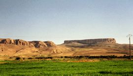
It is permissible to doubt this in the light of recent experience. When we returned to the field in the company of people who had visited the site about twenty years ago, we immediately found ourselves confronted with a choice that is far from simple or without consequences: where to attack the Citadel ? By the North side or the East side? Because, arrived at the foot of the monolithic block by the road (in pitiful condition) of “Kalaat Senan”, about 5 km away, we still have to climb the coast, which has been built up over time, and landslides To reach the single access in degrees, which leads to the flat top of the Table.
To do this, there are only two practicable routes, by the North and the East. The first is certainly the shortest. It can be approached very closely in vehicle and then, on foot, attack the very steep slope which leads, so to speak, to the foot of the stairs arranged a few years ago. It is an escalation of more or less 20 minutes, but damn “physical” and “sportive”. Access by the East is more painful, because noticeably longer. First of all, you have to walk about 3 km by a long pebbly trail like a day without bread, then, on the side of a mountain, about 1.5 km – probably more – on a more or less gentle slope, but less Encumbered than the other way (in time, it was practicable by car). In all, it takes more or less an hour for the entire course.
At the time of the choice to engage either on the left (North side) or on the right (East side), the opinions diverged. Knowing the two trajectories, I pleaded for the second solution, which, at first, has earned me many remonstrances. Access by the North route seems more advantageous because it is more direct, therefore faster and, in the end, less demanding. Only it is carried out by the side where a maximum of scree has accumulated, reducing as much the height of the abrupt wall. It’s less majestic! Next, the angle at the visitor’s view is much narrower than on the opposite side, and the decor, therefore, is much less spectacular. But that’s not all.
Coming from the north, you find yourself directly on the platform overlooking the stairs. On the other side, one follows the southern flank of the Table for a long time, thus offering itself under its greatest angle and in its highest heights. The climbing begins on a gentle slope at the foot of the eastern façade. It continues in winding loops on the mountainside which, in turn, put you in front of the Table or turn away from it to orient you towards the depressions and the surrounding peaks. With each detour, a new painting. But above all, this course is dotted with halts, real historical resorts telling the evolution of life in these places.
From the first stride, my companions fell on fossilized shells: the place was under the waters a few hundred million years ago. At the second lace, on the right, the first megalithic tombs of circular form appear. To the left of a next turn, on an accumulation of countless monumental blocks (detached from the wall long ago), one of these stones welcomes the “House of the married”: where, until recently – To-day, say some – the young husband is led with great pomp on the day of his wedding. It is an excavation practiced in this block in protohistoric times, to serve as funerary vault. Another vestige of the same type, facing him several tens of meters away, welcomed the bride and her suite.
On the way, by carefully scrutinizing the ground and its gray – colored surfaces, flints of flint (sometimes even tiny objects) as well as shells can be detected: they are “escargotières”, tumuli, Prehistoric period of domestic and “industrial” waste as well as ash – hence their name of ramadia, in Arabic.
Finally, at the penultimate turn, where the legend locates the famous fault (clearly visible) through which the Ligurian legionnaire of the Roman historiography would have infiltrated to follow, following the trace of a snail, until The summit of the Table where the partisans of the Numidian Jughurta were entrenched, there are still traces of escargotières and, to the right of the track, dolmenic burials.
Of all this, he who chooses the shortest path sees nothing at all. And yet these are very important aspects of the identity of places.
Tahar Ayachi


{mainvote}

 َAbonnez-vous